Wednesday 23 June 2010

Day Fifteen review

Well a suprising day of hills after what had been a relatively flat area. The difference was that even though each one was slowly conquered, I found myself feeling it was easier than the first two days in Cornwall. Either I felt fitter or the hills were smaller! A nice lunch in Thurso followed up by the final 20 mile, but relatively flat run to John O Groats. It's amazing how active you feel with only 20 miles to go and despite the knowledge of having to ride the 20 miles back, we put in a good effort of about 17mph despite a strong head wind.

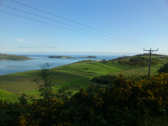
Seeing each sign come closer with an ever shorter mileage pushed us on till we crossed the entrance into John O Groats and to the world famous sign post. 1032 miles, 15 days, 1 puncture, 30 minutes of rain and far too many hours in the saddle. We had the photo taken to prove we made it before a quick drink and then heading off back into the mist that had engulfed the whole village.

The ride back was the best experience with no time constraint, no head wind, no worrying about the next day's ride or directions. Fantastic!

The stats for the day were 65 miles averaging 11.9mph and taking 5hrs 28mins. This does not including the ride back to Thurso!

Sent using a Sony Ericsson mobile phone

Day Fourteen stats

As I didn't get around to putting them on, 50 miles at 11.9mph average taking 4hrs 16mins

Sent using a Sony Ericsson mobile phone

Tuesday 22 June 2010

We've...

Last day...

Already completed 26 miles across the hilly northern tourist road towards John Ogroats with less than 40 miles left to go. The scenery is beautiful and the weather is fantastic, what a great day to complete the ride! We are planning to stop for lunch in Thurso before completing the run to JOG and back. I'll update when we get there!

Sent using a Sony Ericsson mobile phone

Monday 21 June 2010

Day Fourteen review

A nice easy 50 mile day although the weather was certainly not the best weather for it. It was cloudy, windy and at some times rainy but it didn't stop us escaping from it all and enjoying the rural lifestyle.

We managed a few stops in the wilderness of Scotland where we could cycle for 25 miles without seeing any buildings or locals. The road was generally quiet and the going was calm. It was probably on of the most relaxed days we have had so far!

Tongue is quite basic with two shops, two pubs and a petrol pump knocking out diesel at 139.9 a litre! All the shops close at 5pm and the walk from town to the youth hostel is over a mile!

Tomorrow is the final day with 64 miles to John Ogroats and then a nice 20 back to Thurso for the night before we travel the next day. Be reassured there will be a few pics as long as there is signal!

I would give the stats for today but the computer is on the bike in the shed!

Sent using a Sony Ericsson mobile phone

Sunday 20 June 2010

Day Thirteen review

It has been overcast all day today but it hasn't damped our mood for cycling! A nice early set off again got us 22 miles without struggle and resulted in a nice stop at a hotel with a cup of tea and some shortbread. It also involved a bump into the guys from help the heroes again!

A few hills including a 15% incline over a mile provided some hard work as did the usual high north wind however it was worth it for the regular progressive long down hill section allowing speeds of 40mph or more.

This evening involved a couple of pint's at the local pub with the help the heroes guys before getting a good night sleep for our 50 miles to Tongue tomorrow. It should be a nice day with the wind blowing the right way and a few tourist sights on the way.

Stats for today are 60 miles, at 12.2mph on average with 4hrs 52mins in the saddle.
Sent using a Sony Ericsson mobile phone

Saturday 19 June 2010

Day Twelve review

After twelve days of cycling through country lanes and hills, there comes a point where there isn't too much to say... but i'll try anyway!

Today was a good steady day hampered mainly by the 15mph coming from the other direction. The effect the wind has on cycling is profound! Normally the cycling next to a loch would be preferable as the roads are less hilly but today they doubled as wind tunnels! The scenery has been beautiful as ever and not a midgie in sight. We tried to make today more relaxing with longer stops and more breaks throughout the day which is more enjoyable.

The only downside of Scotland is every road is an A or B road meaning traffic going past at 60mph or more and far too close. I also had a near miss with a bus who decided to overtake me the try to pull into a bus stop as I was still next to him.

Loch ness is huge! At over 23 miles long we have managed to cycle along half of it, and will finish it off tomorrow. The hostel is right on the bay and has fantastic views.

Tomorrow is off to Bonar Bridge which is about 60 miles away and as usual the wind is expected to be against us.

Todays stats are 60 miles at an average of 11.7mph taking 5hrs 5mins. Not bad progress!

Sent using a Sony Ericsson mobile phone

Friday 18 June 2010

Day Eleven review

Today was a mixed bag with the first 46 miles being generally quite flat and completing it in just over 3 hours. The second half welcomed our arrival to the highlands with several long progressive hills and heat of over 30 degrees. The views have been fantastic and for once the mileage has been correct! The most amazing bit has to be the pass of glencoe which had an amazing view, about 5 miles downhill and which was only hampered by the ridiculously strong head wind which meant cycling all the way down.

Today is luckily our last long day with all other days being less than 60 miles (except the last day). It either means it gets easier or hillier and i'm yet to find out.

The stats for today are 80 miles, 13.1mph average and 6hrs 9mins. Tomorrow is off to loch ness for a 50 mile ride
Sent using a Sony Ericsson mobile phone

Thursday 17 June 2010

Day Ten review

So after the expected easy relaxing day, we ended up with a few hills that were huge! The largest hill was tak ma doon road which was a spectacular 3 miles constant up hill struggle to the top but as per our policy, we didn't walk an inch of it. The panoramic photo is the view from the top but not sure how well it has come out.

We made it to Stirling about 4.30pm which is our earliest yet but also means we have had the chance to have a look around. The photo of the building is tonights accomodation which is slightly grander than some of our hostels.

Stats for today are 49 miles with 4hrs 52mins in the saddle doing an average of 10.2mph. Tomorrow is a trip to Glencoe with a distance of about 85mph.

Sent using a Sony Ericsson mobile phone

Sun, sun, sun

Another day in the sun so far and a nice laid back one at that! We are a third though our day which is a little hilly but not to excess and after yesterday it is a welcome short and slow day.

We had a nice view earlier over to what we think is probably Glasgow and also a large wind farm in the hills. So all in all, a good day so far!

Sent using a Sony Ericsson mobile phone

Wednesday 16 June 2010

Day Nine review

Well today was a good and bad one. 14 miles in and we managed to cross the border and get into Gretna Green. As with most well know places, it is now very tourist orientated with attractions and photo opportunities. It was a lovely place to stop for tea though and seemed to be a mecca for cyclists on charity rides!

The rest of the day ended up being a heads down ride along a B road next to the motorway for over 60 miles hence the lack of real pics. It was nice to have a flat ride with small gradients however scenery was more than disappointing. It did however mean we arrived in good time and had what was a relatively easy day.

The stats for today are 82 miles, taking 6hrs 31mins at an average pace of 12.6mph.

Tomorrow is off to Sterling which is noted as a 42 mile day so it'll be a short one for us!

Sent using a Sony Ericsson mobile phone

Scotland finally..

Finally arrived in Scotland to find someone had thought it a good idea to foul behind the sign. So obviously we didn't stick around for too long! We've made it as far as Gretna to see the bagpiper and the marriage rooms before we head off again to Lockerbie. Hopefully a nice, flat ride ahead today and despite what they say about Scotland, we have glorious sunshine for miles ahead!

Sent using a Sony Ericsson mobile phone

Tuesday 15 June 2010

Day Eight review

Another tough day has been and gone with constant hills and climbs throughout the day but exploring another part of the country you would normally miss by car and motorway. From the hills out of Slaidburn to the fast down hill drops, we've had some beautiful sights.

Now over half way through, we are due to enter Scotland tomorrow at Gretna quite early on with another long but hopefully not so hilly day. It'll be nice to have just a decent long distance but flat day!

Stats for today are 84 miles, taking 7hrs 46mins with an average of 10.8mph. The grand total so far is 581 miles!

Sent using a Sony Ericsson mobile phone

Sunshine and hills

Now at the 60 mile mark, we started off with some pretty big hills leave Tobay. After a while the terrain flattened out which made it all a bit easier. Only another 22.5 miles according to Google maps!

Sent using a Sony Ericsson mobile phone

Welcome to the Dales!

After a short technological blackout, we are finally back in contact with the world. Well for now anyway!

Today is a good point for us being half way through our ride. By the end of today, we will be stopping just short of Scotland in Brampton.

It has been tough going most of the day as we entered the Yorkshire Dales and have been riding along the hilltop paths for most of the day. Such beautiful views from the top and some fantastic downhill stretches but certainly not enough to get you back up the other side.

We also met up with a group of riders we last saw on day two in Cornwall when we had cream tea. They stayed in the same hostel last night and we have been leapfroging each other most of the way.

So although a grueling day, a positive start to it!

Sent using a Sony Ericsson mobile phone

Monday 14 June 2010

Day Seven review

Well today started well with a complete black out on the o2 data meaning no email, google maps, tracking or blog updates all day. A good nights sleep set us up well for the busy A road start out of Chester. Soon enough we were out into the ruralish areas set between Manchester and Liverpool. What shocked me most was that despite being in such a built up area, it seemed pretty rural.

Not being the travelling type, I haven't spent much time up north but what suprised me the most was the state of some of the towns. The villages clearly had a pleasant and welcoming feel when a town like Leigh was the complete opposite with boarded up houses, closed businesses and brand new but empty office blocks. The collection of locals outside the job centre looked like the usual lame, useless and unemployable. Despite being around time for a break, we decided against it and waited till a little further on.

It was described as a long hard day which by 60 miles I had laughed off. The terrain was hilly but nowhere near the continuity of Cornwall. As soon as we had again set off, we had to battle 27 miles of hills on top of the mileage already completed. As such, We arrived tired, cold and sore. Tomorrow is yorkshire dales ending in Brampton at a distance of about 85 miles. I won't be happy!
Stats 86 miles, average 11.5mph taking 7hrs 30mins
Sent using a Sony Ericsson mobile phone

Sunday 13 June 2010

Never trust sat-nav

Just an observation, but we checked google to see the distance between Chester and Slaidburn and it came up at 190 miles. It wasn't till we saw the recommended route took a ferry to the isle of man and back again that we realised the error!

Sent using a Sony Ericsson mobile phone

Day Six review

Well today has been good. Despite riders coming the other way saying how difficult it was, we've breezed through the day from Clun to Chester. Sorry for the lack of entries but once we got going, we found it difficult to stop! After a short detour early on, we managed to find our route and get back to where we were suppose to be.

There has been a lot of interest from people as we've been going around asking where we were going and it has been nice to meet various walkers, cyclists and locals. It's amazing how much there is to look at throughout the route with miles of countryside around us.

We managed to get most of the run out of the way before it rained 10 miles outside of Chester. Luckily the waterproof kit did it's job and protected us from the worse of it.

Anyway, the stats are 71 miles, at average of 11.5mph taking 6hrs 12mins.

Sent using a Sony Ericsson mobile phone